Exploring the Blue Horizon: Ancient Navigators and Their Contemporary Currents
The Thought
The histories of the Pacific Islands share a common thread that ties their beginnings to a group of ancient navigators. Skilled seafarers, whose civilization is understood to have origins in Papua New Guinea via Taiwan, would leave their home and set their eyes on the blue horizon. Their mastery of oceanic navigation would guide them away from their familiar waters and take them to new islands. Their migration and settlement of the discovered islands would create the different cultures of the Pacific Islands. Thousands of years of history have been preserved through oral histories and genealogies that are as diverse as the islands themselves. This origin story reflects the relationship between communities and the sea that are inextricable to Pacific Island cultures.
After the Age of Colonization, the art and knowledge of traditional navigation was on the verge of disappearing. There were very few master navigators to pass on their knowledge. In 1976, the Hokule’a was built as a traditional Polynesian vessel and a Satawalese navigator named Mau Piailug would teach the crew how to navigate by the stars, sky and waves. The Hokule’a honors and remembers the ties of Pacific Islanders to the ocean and to their ancestors who explored the ocean thousands of years before.
This resource list was developed to help students understand the early migrations of the ancient navigators and to have them explore the mastery involved with traditional navigation and the potential loss of that knowledge due to the influence of foreign colonizers.
Student Objectives
- Understands the importance of ancient histories to the contemporary connections of oceanic navigation and voyages of Pacific Islander communities.
- Investigates how traditional navigation is a complex scientific system connecting knowledge of tides, oceanic knowledge and stars.
- Understands the importance of seafaring in developing Pacific Island culture.
Presentation on Ancient Migration (Recommended for K-3rd grade)
This introductory presentation briefly outlines the ancient movements of the Lupita people by following their exploration and migration to Pacific Islands.
Note: It is important to contextualize migration of the Lupita people as ancient—during the time period of Ancient Egypt and of the beginnings of Ancient Greek civilization. In context, the scope of the journey is even more impressive.
Resources on ancient migration and traditional navigation and wayfinding:
Articles on the Web:
- Huakaʻi Neʻekau Kumukahi is a fantastic website dedicated to bringing living Hawaiian culture and history to students and classrooms. Ancient migrations are shared in student-friendly ways–describing reasons for leaving; what the ancestors had taken with them, methods of navigation and how stories and genealogies are passed through story. On this page they have a great video teaching about ancient migration to journeys taken between Kahiki (Samoa, Tahiti and the Cook Islands) and Hawaii .http://www.kumukahi.org/units/ka_hikina/huakai_neekau
- Pacific Migrations: Great resource for many different concepts that have influenced the identity of New Zealand. Following article focuses on the ancient migration of the Lupita people http://www.teara.govt.nz/en/map/1767/sites-of-lapita-pottery
- Polynesia’s Genius Navigators: Concise Nova article about Pacific Navigators through western comparisons, http://www.pbs.org/wgbh/nova/ancient/polynesia-genius-navigators.html
- On Wayfinding: Article written by a current navigator, Nainoa Thompson, of the Hokule’a on the method of traditional navigation. There is a diagram of the language of directions and their corresponding star waypoints. Article puts into perspective the multiple factors that go into navigation. http://pvs.kcc.hawaii.edu/ike/hookele/on_wayfinding.html
- Predicting Weather: Reading Clouds and Sea States: Nainoa Tompson’s article detailing the routine of looking at weather patterns while voyaging—evocative images of the open ocean. http://pvs.kcc.hawaii.edu/ike/hookele/reading_clouds_and_sea_states.html
Videos Clips and Movies
- The Navigators: Pathfinders of the Pacific: Documentary from the 1970’s on Pacific Navigators and tells the story of Mau Paliug, a master navigator that taught way finding to the crew of the Hokule’a. Teaches about the Lapita people’s ancient oceanic journey and also mentions contrasting movement theory of Thor Heyerdahl’s Kontiki. https://www.youtube.com/watch?v=uxgUjyqN7FU
- Messages from the Ocean People of Island Earth: Video connecting the journey of the ancient navigators and how their traditions continue through the journey of the Hokule’a. Details how the Hoku’lea and its crew are dedicated to fight for ocean conservancy. http://www.hokulea.com/malama-honua-declarations/
Books
- Nunes, Susan. To Find The Way. Hawaii. University of Hawaii Press. 1992.
- Developed in part by the Hokule’a Project, this picture book follows a young boy who embarks on an ocean voyage with his family. His Grandfather is the navigator and he watches him read the wind and waves. (recommended for 1st-4th grade)
- Sperry, Armstrong. Call It Courage. Simon and Schuster Books for Young Readers. 1968.
- This chapter book looks back in time and follows a young Hikueru Island boy and is a coming of age novel. Mafatu is scared of the ocean but overcomes his fears to prove his worth to himself and his community. The book does contain language that is outdated and should be addressed before reading the novel. The book can be checked out from the Seattle Public Library. (recommended for 3rd-5th graders)
Activity Navigating our Stars
The activity challenges students to find and identify the Big Dipper or Na’Hiku (“ The seven” as it is known in Hawaiian), the North Star or Hokupa’a (“The Immovable Star” in Hawaiian) and the Little Dipper in the night sky. Through using celestial bodies as beacons, the students will find and record the direction north. The activity works best as a take home assignment.
Recommended Grade Level: 1st-3rd
The ancient pacific island navigators would set sail and would take long journeys on the ocean. As they left their island homes, it might be as many as 30 days before they saw land once again. On the open ocean they would need to use the stars to give them their directions.
Materials
Pencil
Paper
(Optional) Printed Starmaps Example 1 and Example 2
Instructions
As a class, lead a discussion on star navigation as a tool that the ancient navigators would learn to master.
Introduction discussion questions to ask:
- Has anyone been on a boat on the open ocean? Imagine as you sail further from shore that the beach that you have left gets smaller and smaller until it is just a speck. You look forward, backward, left and right—you only see miles and miles of water. How do you know the direction that you are going?
- What are some waypoints you could use around you?
- Can you name any stars or constellations? All around the world people have gazed up at the sky and noticed patterns. To remember stars and to remember people, stories have been attached to the stars in the sky. By naming star patterns it is easier to recognize what part of the sky you are looking at.
- Stars like the North Star are fixed from our perspective on earth. They are unmoving and are the perfect waypoints for navigating.
Have the students look at Example 1 from the navigators of the Hokule’a.
- Do you recognize any of the constellations in the diagram?
- Are their names different from what you know them as?
Have the students try to read out loud the names of the Big Dipper and Polaris. Encourage the students to read the bottom of the star chart. Below the line are the Hawaiian words for the directions as well as the horizon areas that the stars appear.
The North Star is very easy to find if you look for the Big Dipper and the Little Dipper. The Northstar is a part of the handle of the Little Dipper. If you can find the Big Dipper follow the edge of the bowl and look for the bright star near the edge.
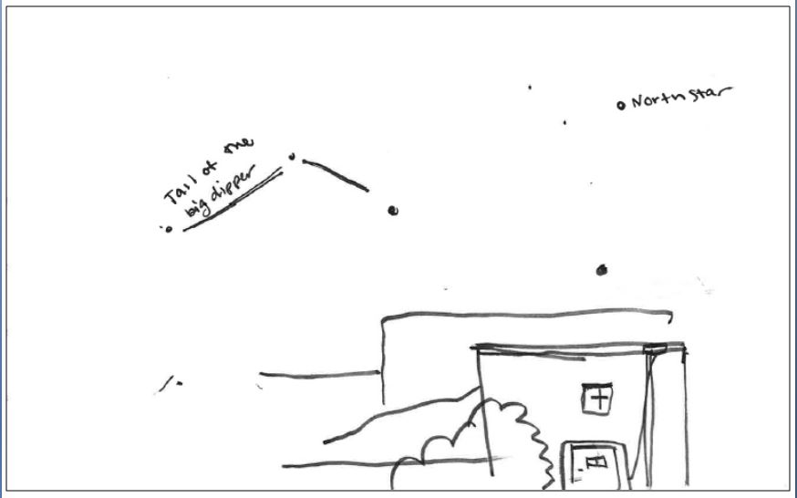
For the students take home assignment, ask them to do a sketch of the night sky outside of their home. Have them sketch out the Big Dipper and the North Star. Ask them to draw the skyline/horizon of where the North Star appears. The skyline could be a part of their house, neighborhood or even a part of the city skyline. With the direction of the stars, they will be able to identify north in their neighborhood.
Let them know that might be difficult to see the stars in the city itself because of the bright lights that mask the twinkle of the stars. In the Sample Drawing the sketch artist could not make out all of the stars of the Big Dipper because of the light of the city. Students should be encouraged to try their best and sketch out the stars that they can see. Because the drawing is a sketch, remind the students that it doesn’t need to be perfectly drafted.
When the students return to the classroom, they should share their drawings and reflect on their observations.
- What was difficult about the assignment?
- Were they able to identify the North Star?
- Did they notice anything about their neighborhood as they sat and observed the stars?
Example 1 Hawaiian Star Map from Hokulea Voyage
Source:
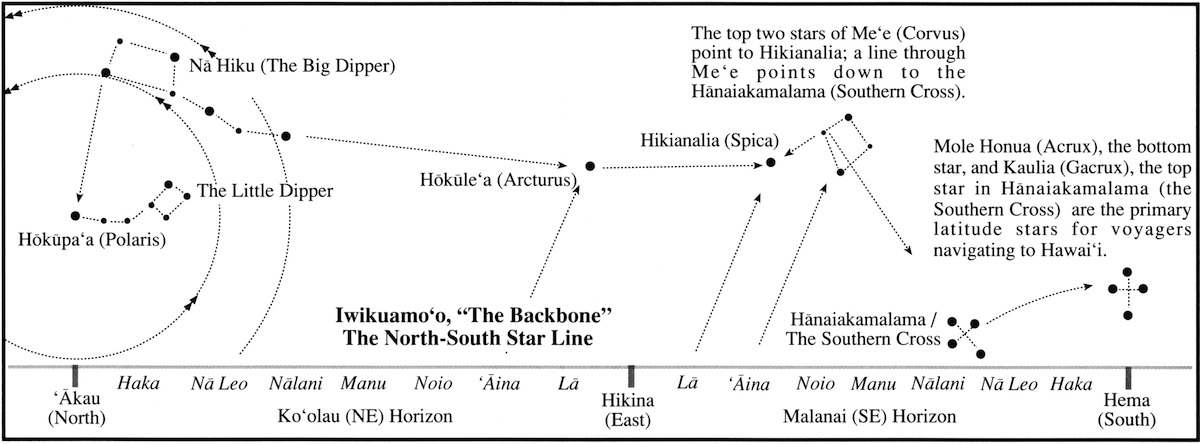
http://pvs.kcc.hawaii.edu/ike/hookele/starlines_rising_and_setting.html
Example 2: Starmap from Earthsky
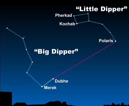
Source http://earthsky.org/brightest-stars/polaris-the-present-day-north-star
Sample Drawing